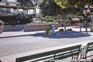
Around Town Square, September 1966
I wonder if I could spend the better part of a day at Disneyland without ever leaving Main Street? Maybe not, but I could definitely pass many hours there - something that I could never imagine doing years ago.
This first photo shows one of the busy sweeps, all in white. He's sticking to the shade as much as possible... it can be awfully hot in September, which I just think of as "August: Part Two". Patriotic bunting remains near the train station, possibly from the 4th of July (who knows, perhaps these pictures were taken closer to that date).
Zooming in a bit, we get a tantalizing glimpse of a souvenir stand; Notice the distinctive triangular outline of Disneyland on a displayed souvenir wall map. You can even see that it is definitely a 1966 map, the first that wasn't drawn by Sam McKim. If you look carefully to the right of that, you can see the white blouse and red vest of a tour guide. Love the colorful Mickey balloons.
Here's a nice jpeg of the 1966 map for you!
Nearby, a hay-burning Streetcar clip-clops around Town Square to head north toward the castle.
Did somebody call a nurse? Perhaps that lady worked in food services, or... could she just be a guest? A water fountain (without the C&H sugar bag) is to the right of her. We can also see the Global Van Lines vehicle, while a surrey seems to be heading backstage.


13 comments:
The "nurse's" costume kind of resembles the "Lost Children" cast member costume from this 2012 post. But it's hard to say without a clearer picture
I want to have that sweep's job! It looks so carefree and relaxing, especially on a quiet day.
I never realized that Space Mountain was in DL in 1966. I thought the Disney World had the 1st SM and DL bulit their version after that. Wonder pictures again Major! Thank you.
What's the difference between the 1966 and 1968 maps? I have a 1968 framed on my office wall, and I can't find any differences. Help!
Stu29573, comparing 1966 to 1968 map:
The House of the Future is removed and replaced by Alpine Gardens in the 1968 map.
The two small buildings inside the Main Gate Entrance on each side are larger in the 1968 map and extended outside the gates so guests have access to purchase souvenirs or do customer service/stroller rentals? both inside and outside the park.
The blue X in white circle(future attraction) is removed from the Carousel of Progress in the 1968 map as it becomes a current attraction.
There are several label changes on the Golden Horseshoe/Davy Crockett Arcade building from 1966 to 1968.
There are label changes on the Tomorrowland Terrace complex. I think it originally said "Art Corner" nearby the Terrace in the 1966 map and in the 1968 map the Terrace finally gets labeled.
There might be a few others, but that's what I found.
Hope that answers your question.
Major, One of my biggest disappointments with modern day Disney Parks merchandising is that they no longer sell the park wall maps or pictorial souvenir booklets like they did in the old days. Also, current postcards seem harder to find at the parks these days.
Luckily I have several wall maps of Disneyland, DCA, Magic Kingdom and EPCOT Center which I purchased when visiting those parks back in the day. Nice post today! Thanks, Major.
I'm with Major, I would spend a lot more time meandering through Main Street as an adult. I was just a ride junkie as a kid, and didn't really appreciate the beauty of it until I was a teen. I also enjoy New Orleans Square, especially at night. I love Disneyland art, and the epitome of cool is a park map. The older ones are getting harder to find and sell for mega bucks on auction sites. Maybe our nurse has been summoned to assist one of the streetcar riders with a motion sickness problem. Thanks Major.
The map--what a layout. Even with some of the big attractions still in the future, this is the Disneyland frozen (not "Frozen") in the scale model at the Walt Disney Museum in San Francisco. And thanks Major for preserving that park here.
Melissa, I do think that the lady in question is a CM, but her outfit looks a little different than the cute one you linked to. However, the costumes evolved often, so… she might be a “Lost Children” matron, or even the on-staff nurse.
Penna. Andrew, I have spoken to guys who used to be sweeps, and they said it was the best job!
Gnometrek, I was thinking, “Space Mountain? 1966??” (having forgotten about the map). Yes, they included that ride on the maps way back in ’66, even though the WDW version debuted in 1975, and in Disneyland in 1977.
Stu29573, I was all set to do a little research, but I see that Ken has already done it for me!
K. Martinez, you had all the fun! But I appreciate you doing the work so that I can take a little early-morning nap.
K. Martinez, the strange thing is that they sold big maps into the 2000’s (after a break); maybe they’ll come back. I would think that they would sell a nice color souvenir pictorial like hotcakes, especially if they changed it annually like in the old days. I love my old maps - I have all of the older ones, but surprisingly, some of the later examples were too expensive so I never got copies.
Jonathan, there were things I liked on Main Street, such as Mr. Lincoln, or the Emporium windows, but I mostly fast-walked to other destinations! If I could do a day at the park without 60,000 other people, I’d love to ride all of the Main Street vehicles. The nurse looks worried, and hopes that she hasn’t discovered the first case of ebola.
Stefano, I’ve mentioned it before, but I have one of those maps that literally fell to pieces - 12 individual panels. I couldn’t bear to throw them away, so I still have them somewhere!
@Gnometrek. As a kid, I had (may still have?) a copy of the 1968 map and it used to make me crazy with anticipation for Space Mountain.
Now, thanks to the Major, I have the 1966, 1968 and 1976 amber background maps and one older one by Sam McKim, all in electronic format. Many, many thanks to the Major.
I will keep these electronic ones on my iPad and drool over them in my rocking chair in the home.
Such terrific pictures of main street today. Fraught with mystery and intrigue. Especially the nurse. What is going on there?
JG
My immediate reaction to the first pic is that she is in a nurse's costume. There were times guests would come to Guest Relations in City Hall to report a health problem, so she may have been on her way back to the First Aid trailer backstage...the most direct route being through the gate between Mr. Lincoln and Hills Bros. The fascinating thing is that we will never really know. KS
JG, it must have been the earlier map (before they added Space Mountain), but I remember looking at those and seeing LARGE areas that were just trees, and wondering, “WHY aren’t they putting rides there??”. Not realizing that those were backstage areas for employees. Doh. I have some very high res vintage map jpegs, even now I just love to look at them.
KS, it was probably another case of Boogie Fever. Luckily there was a cure - listening to the “It’s a Small World” theme!
@Major, the extensive trees in the backstage areas are just following my architecture rendering instructor's tip; "If there is some feature of the perspective or the building that you can't figure out, draw a tree in front of it".
It's a time-honored trick in the industry.
JG
Post a Comment